Location: Chifeng 🌎
Location: Chifeng, China
Administration Region: Inner Mongolia
Population: 4341245
ISO2 Code: Inner Mongolia
ISO3 Code: CHN
Location Type: Lower-level Admin Capital
Latitude: 42.257
Longitude: 118.888
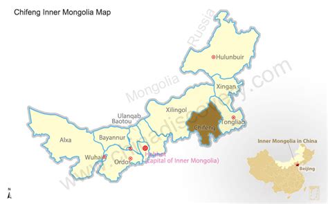
Chifeng (Chinese: 赤峰市), also known as Ulanhad (Mongolian: ᠤᠯᠠᠭᠠᠨᠬᠠᠳᠠ ᠬᠣᠲᠠ (Улаанхад хот), Ulaɣanqada qota, [ʊlaːnxad xɔt], “red cliff”), is a prefecture-level city in Southeastern Inner Mongolia, People’s Republic of China. It borders Xilin Gol League to the north and west, Tongliao to the northeast, Chaoyang (Liaoning) to the southeast and Chengde (Hebei) to the south. The city has a total administrative area of 90,275 square kilometres (34,855 sq mi) and as of the 2020 census, had a population of 4,035,967 inhabitants (4,341,245 in 2010). However, 1,175,391 of those residents lived in the built-up (or metro) area made of the 2 urban districts of Hongshan and Songshan, as Yuanbaoshan is not conurbated yet. However, a large part of Songshan is still rural and Yuanbaoshan is a de facto separate town 27 kilometers away from the core district of Chifeng. The city was the administrative center of the defunct Ju Ud League (昭乌达盟; ᠵᠤᠤ ᠤᠳᠠ ᠴᠢᠭᠤᠯᠭᠠᠨ).

Top Chifeng HD Maps, Free Download 🗺️
Map
Maps
United States
United States
World Map
China
China