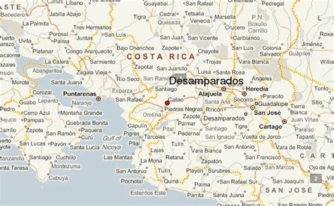
Location: Desamparados 🌎
Location: Desamparados, Costa Rica
Administration Region: San José
Population: 33866
ISO2 Code: San José
ISO3 Code: CRI
Location Type:
Latitude: 9.8114
Longitude: -84.029
Desamparados is the 3rd canton in the province of San José in Costa Rica. The canton covers an area of 118.26 km², and has a population of 206,708, making it the third most populated among the 81 cantons of Costa Rica. The capital city of the canton is also called Desamparados.
The canton begins in the southern suburbs of the national capital city of San José, with the Río Tiribí marking its northern boundary. It snakes its way south in the shape of a backward ´S´, finally reaching its southern limit at the Río Tarrazú. It contains the bigger of the last forest lungs in the metropolitan area of Costa Ricans capital, the Loma Salitral, which conservation issues have generated social conflicts between community environmentalist and immobiliary developers, as it is seen as an identity mark of the desamparadeño people and a very important infiltration area to prevent the frequents and disastrous floods in the district of Gravilias.Urban areas claim 80.4% of the canton’s population. Those under age 10 make up 19.8% of its inhabitants, while 5.1% are over 65.

Top Desamparados HD Maps, Free Download 🗺️
Map
Maps
United States
United States
World Map
China
China