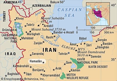
Location: Hamadān 🌎
Location: Hamadān, Iran
Administration Region: Hamadān
Population: 554406
ISO2 Code: Hamadān
ISO3 Code: IRN
Location Type: First-level Admin Capital
Latitude: 34.7983
Longitude: 48.515
Hamadan (pronounced [hæmedɒːn]) or Hamedan (Persian: همدان, Hamedān) (Old Persian: Haŋgmetana, Ecbatana) is the capital city of Hamadan Province of Iran. At the 2019 census, its population was 783,300 in 230,775 families. The majority of people living in Hamadan identify as ethnic Kurds and Persians.
Hamedan is believed to be among the oldest Iranian cities. It is possible that it was occupied by the Assyrians in 1100 BCE; the Ancient Greek historian, Herodotus, states that it was the capital of the Medes, around 700 BCE.
Hamedan has a green mountainous area in the foothills of the 3,574-meter Alvand Mountain, in the midwest part of Iran. The city is 1,850 meters above sea level.
The old city and its historic sites attract tourists during the summer to this city, located approximately 360 kilometres (220 miles) southwest of Tehran. The major sights of this city are the Ganj Nameh inscription, the Avicenna monument and the Baba Taher monument. The main language in the city is Persian.

Top Hamadān HD Maps, Free Download 🗺️
Map
Maps
United States
United States
World Map
China
China