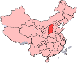
Hejin (Chinese: 河津; pinyin: Héjīn) is a county-level city of Yuncheng City, in the southwest of Shanxi province, People’s Republic of China, located on the east (left) bank of the Yellow River. It borders Jishan and Wanrong counties to the east and south, Linfen to the north, and Hancheng in Shaanxi across the Yellow River to the west. As of 2002, it had a population of 360,000 residing in an area of 593 km2 (229 sq mi). The city and its surrounding area is home to abundant aluminium reserves. During the Qin Dynasty, Hejin was known as Pishi County (皮氏县; Píshì Xiàn), renamed to Longmen County (simplified Chinese: 龙门县; traditional Chinese: 龍門縣; pinyin: Lóngmén Xiàn) during the Northern Wei, and finally Hejin County (河津县; Héjīn Xiàn) in the Song Dynasty. The city’s name (河津) literally means “river ford”, due to the need of a fording of the Yellow River at the time. In 1994, Hejin was upgraded to its present status as a county-level city.