Location: Hinunangan 🌎
Location: Hinunangan, Philippines
Administration Region: Southern Leyte
Population: 29149
ISO2 Code: Southern Leyte
ISO3 Code: PHL
Location Type:
Latitude: 10.4
Longitude: 125.2
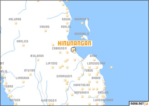
Hinunangan, officially the Municipality of Hinunangan (Kabalian: Lungsod san Hinunangan; Cebuano: Lungsod sa Hinunangan; Tagalog: Bayan ng Hinunangan), is a 3rd class municipality in the province of Southern Leyte, Philippines. According to the 2020 census, it has a population of 29,149 people. Hinunangan is known as the “Rice Granary of the Province” for its vast plain land that is entirely planted with rice. Hinunangan has great potential for tourism because of its beautiful sandy beaches and islands. The town is also a producer of rattan and wood-based furniture, abaca handicraft items, pineapple, vegetables, other forest products, and bamboo furniture. It has a potential for mineral water and root crop processing and copper mining.Hinunangan is also known as a major gateway in Leyte because of its near proximity to Tacloban City. The opening of Abuyog–Silago Road cuts travel time from Tacloban by half from the previous 6 hours to less than 3 hours. It is also the place in Southern Leyte with the most immigrants from Europe and North America.
It has a lot of tourist places, such as Tahusan, Talisay, or the twin islands (known as Cabugan Grande and Cabugan Chico as Pigafetta stated in his account during their travel with Magellan).. There are also hotels, inns, a public market, and beach resorts.

Top Hinunangan HD Maps, Free Download 🗺️
Map
Maps
United States
United States
World Map
China
China