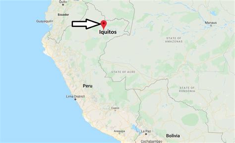
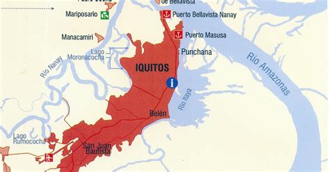
Iquitos ( ; Spanish pronunciation: [iˈkitos]) is the capital city of Peru’s Maynas Province and Loreto Region. It is the largest metropolis in the Peruvian Amazon, east of the Andes, as well as the ninth-most populous city in Peru. Iquitos is the largest city in the world that cannot be reached by road that is not on an island; it is only accessible by river and air.It is known as the “capital of the Peruvian Amazon”. The city is located in the Great Plains of the Amazon Basin, fed by the Amazon, Nanay, and Itaya rivers. Overall, it constitutes the Iquitos metropolitan area, a conurbation of 471,993 inhabitants consisting of four districts: Iquitos, Punchana, Belén, and San Juan Bautista.
The area has long been inhabited by indigenous peoples. According to Spanish historical documents, Iquitos was established around 1757 as a Spanish Jesuit reduction on the banks of the Nanay River. The Jesuits gathered local Napeano (Yameo) and Iquito natives to live here, and they named it San Pablo de Napeanos.
In the late 19th century, during the Amazon rubber boom, the city became the center of export of rubber production from the Amazon Basin and was the headquarters of the Peruvian Amazon Company (PAC). The city’s economy was highly dependent on the PAC, controlled in the nation by Peruvian businessman Julio César Arana. PAC kept indigenous workers in near slavery conditions through use of force and harsh treatment, until an investigation caused a reaction against the company. In addition, rubber seedlings had been smuggled out of the country and cultivated on plantations in Southeast Asia, undercutting prices of the Peruvian product. With the decline of the rubber industry, many workers and merchants left Iquitos.
As one of the leading cities, along with Manaus, during the Amazon rubber boom (1880–1914), Iquitos was influenced by the numerous Europeans who flocked to it. Architecture and cultural institutions established during this period expressed their own traditions. An opera house and Jewish cemetery were among the institutions established.
Later in the 20th century, the city and region diversified its economy. The region exported timber, fish and its by-products, oil, minerals, and agricultural crops. It also derives revenue from tourism and related crafts. In 1999, the city consolidated its four municipalities.