Location: Karūr 🌎
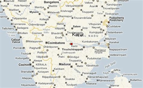
Location: Karūr, India
Administration Region: Tamil Nādu
Population: 358468
ISO2 Code: Tamil Nādu
ISO3 Code: IND
Location Type:
Latitude: 10.9601
Longitude: 78.0766
Karur (Tamil: [kaɾuːɾ]) is a city in the Indian state of Tamil Nadu. Karur is the administrative headquarters of Karur district. It is located on the banks of River Amaravathi, Kaveri and Noyyal.
Karur is well known for the export of Home Textile products to USA, UK, Australia, Europe and many more countries. It is situated at about 395 kilometers southwest of the state capital Chennai, 75 km from Tiruchirappalli, 120 km away from Coimbatore, 295 km away from Bengaluru and 300 km away from Kochi.

Top Karūr HD Maps, Free Download 🗺️
Map
Maps
United States
United States
World Map
China
China


