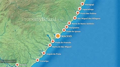
Location: Maragogi 🌎
Location: Maragogi, Brazil
Administration Region: Alagoas
Population: 32940
ISO2 Code: Alagoas
ISO3 Code: BRA
Location Type:
Latitude: -9.0122
Longitude: -35.2225
Maragogi is a municipality in the Brazilian state of Alagoas, 125 km north of the capital city of Maceió. It has 33,032 inhabitants, a city situated on the northern coast of Alagoas state, Brazil, being the easternmost city of that state.
As the main destination in the State of Alagoas after its capital city, Maragogi attracts visitors from Maceió. From Japaratinga beach, on the southern tip, a ferryboat crosses Manguaba River into Porto das Pedras, where visitors find virtually deserted beaches. Maragogi was initially a small village called Gamela. In 1887, it was granted the status of an adopted the name of Isabel, to honor the Brazilian Princess who signed a law ending slavery in Brazil. Later on, in 1892, it was named as Maragogi after the river that baths the city. “Maragogi”, according to some historians, comes from “Marahub-gy”, or river of the Marauba tribes.
Top Maragogi HD Maps, Free Download 🗺️
Map
Maps
United States
United States
World Map
China
China


