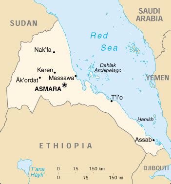
Massawa ( muh-SAH-wuh; Tigrinya: ምጽዋዕ, romanized: məṣṣəwaʿ; Ge’ez: ምጽዋ; Arabic: مصوع; Italian: Massaua; Portuguese: Maçuá) is a port city in the Northern Red Sea region of Eritrea, located on the Red Sea at the northern end of the Gulf of Zula beside the Dahlak Archipelago. It has been a historically important port for many centuries.
Massawa was the capital of the Italian Colony of Eritrea until the seat of the colonial government was moved to Asmara in 1897.Massawa has an average temperature of nearly 30 °C (86.0 °F), which is one of the highest experienced in the world, and is “one of the hottest marine coastal areas in the world.”