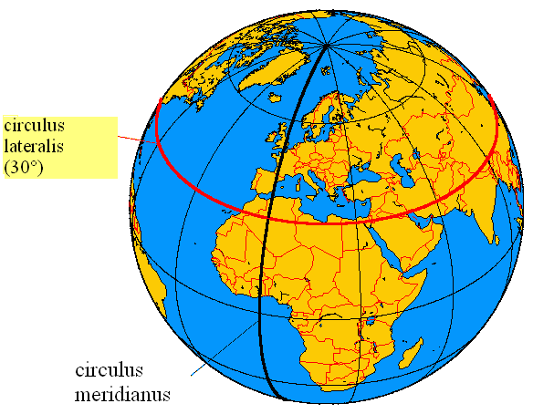
The historic prime meridian or Greenwich meridian is a geographical reference line that passes through the Royal Observatory, Greenwich, in London, England. The modern IERS Reference Meridian widely used today is based on the Greenwich meridian, but differs slightly from it. This prime meridian (at the time, one of many) was first established by Sir George Airy in 1851, and by 1884, over two-thirds of all ships and tonnage used it as the reference meridian on their charts and maps. In October of that year, at the behest of US President Chester A. Arthur, 41 delegates from 25 nations met in Washington, D.C., United States, for the International Meridian Conference. This conference selected the meridian passing through Greenwich as the world standard prime meridian due to its popularity. However, France abstained from the vote, and French maps continued to use the Paris meridian for several decades. In the 18th century, London lexicographer Malachy Postlethwayt published his African maps showing the “Meridian of London” intersecting the Equator a few degrees west of the later meridian and Accra, Ghana.
The plane of the prime meridian is parallel to the local gravity vector at the Airy transit circle (51°28′40.1″N 0°0′5.3″W) of the Greenwich observatory. The prime meridian was therefore long symbolised by a brass strip in the courtyard, now replaced by stainless steel, and since 16 December 1999, it has been marked by a powerful green laser shining north across the London night sky.
Global Positioning System (GPS) receivers show that the marking strip for the prime meridian at Greenwich is not exactly at zero degrees, zero minutes, and zero seconds but at approximately 5.3 seconds of arc to the west of the meridian (meaning that the meridian appears to be 102 metres east). In the past, this offset has been attributed to the establishment of reference meridians for space-based location systems such as WGS 84 (which GPS relies on) or that errors gradually crept into the International Time Bureau timekeeping process. The actual reason for the discrepancy is that the difference between precise GNSS coordinates and astronomically determined coordinates everywhere remains a localized gravity effect due to vertical deflection; thus, no systematic rotation of global longitudes occurred between the former astronomical system and the current geodetic system.