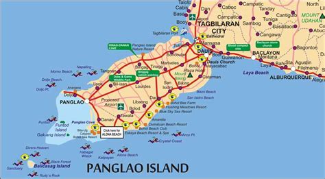
Location: Panglao 🌎
Location: Panglao, Philippines
Administration Region: Bohol
Population: 39839
ISO2 Code: Bohol
ISO3 Code: PHL
Location Type:
Latitude: 9.5667
Longitude: 123.775
Bohol–Panglao International Airport (Cebuano: Tugpahanang Pangkalibutanon sa Bohol–Panglao; Filipino: Paliparang Pandaigdig ng Bohol–Panglao; IATA: TAG, ICAO: RPSP), also known as New Bohol International Airport, is an international airport on Panglao Island in the province of Bohol, Philippines. The airport opened on November 28, 2018 after decades of planning and three years of construction, replacing Tagbilaran Airport to support Bohol’s increased passenger traffic due to tourism. The airport serves as the gateway to Tagbilaran and the rest of mainland Bohol for domestic air travellers. It also is less than an hour’s flight from Mactan–Cebu International Airport, which is a gateway to central Philippines for international tourists.
Dubbed as the first eco-airport in the Philippines and the country’s green gateway, the airport is located at a 230-hectare (570-acre) site in Barangay Tawala in Panglao.
While the airport is billed as an international airport – with Jeju Air being its sole international airline – it is classified as Class 1 principal domestic airport by the Civil Aviation Authority of the Philippines.

Top Panglao HD Maps, Free Download 🗺️
Map
Maps
United States
United States
World Map
China
China