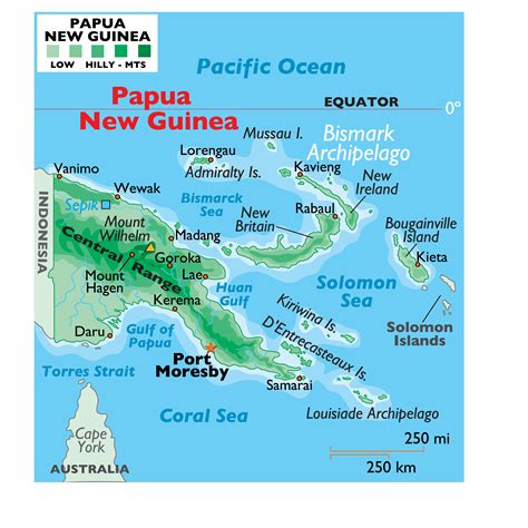
Papua New Guinea (abbreviated PNG; , also US: ), officially the Independent State of Papua New Guinea (Tok Pisin: Independen Stet bilong Papua Niugini; Hiri Motu: Independen Stet bilong Papua Niu Gini), is a country in Oceania that comprises the eastern half of the island of New Guinea and its offshore islands in Melanesia (a region of the southwestern Pacific Ocean north of Australia). Its capital, located along its southeastern coast, is Port Moresby. The country is the world’s third largest island country, with an area of 462,840 km2 (178,700 sq mi).At the national level, after being ruled by three external powers since 1884, including nearly 60 years of Australian administration starting during World War I, Papua New Guinea established its sovereignty in 1975. It became an independent Commonwealth realm in 1975 with Elizabeth II as its queen. It also became a member of the Commonwealth of Nations in its own right.
There are 839 known languages of Papua New Guinea, one of the most linguistically diverse countries in the world. As of 2019, it is also the most rural, as only 13.25% of its people live in urban centres. Most of the population of more than 8 million people live in customary communities. Although government estimates have placed the country’s population at 9.4 million, it was reported in December 2022 that a yet-to-be-published study suggests the true population is close to 17 million.The country is believed to be the home of many undocumented species of plants and animals.The sovereign state is classified as a developing economy by the International Monetary Fund; nearly 40% of the population are subsistence farmers, living relatively independently of the cash economy. Their traditional social groupings are explicitly acknowledged by the Papua New Guinea Constitution, which expresses the wish for “traditional villages and communities to remain as viable units of Papua New Guinean society” and protects their continuing importance to local and national community life. Papua New Guinea has been an observer state in the Association of Southeast Asian Nations (ASEAN) since 1976, and has filed its application for full membership status. It is a full member of the Commonwealth of Nations, the Pacific Community, and the Pacific Islands Forum.