Location: Salay 🌎
Location: Salay, Philippines
Administration Region: Misamis Oriental
Population: 29998
ISO2 Code: Misamis Oriental
ISO3 Code: PHL
Location Type:
Latitude: 8.87
Longitude: 124.8
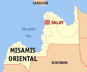
Salay, officially the Municipality of Salay (Cebuano: Lungsod sa Salay; Tagalog: Bayan ng Salay), is a 4th class municipality in the province of Misamis Oriental, Philippines. According to the 2020 census, it has a population of 29,998 people. The town is known for its handmade paper and papercrafts, similar to washi, but made with indigenous fibers.Poblacion is the center of Salay and had been governed by the Capistrano politicians until the 2007 elections. Lanzones is one of the major source of income among Salayanos aside from commerce at Poblacion and fishing to other people. May 1 is the official feast day of Salay although March feast is also celebrated and is the original.
Salay Central School provides primary education to the graders in this town while the nearby Salay National High School provides the secondary education, the latter has been nationally recognized for quality education among public schools.

Top Salay HD Maps, Free Download 🗺️
Map
Maps
United States
United States
World Map
China
China
