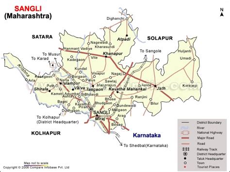
Sangli (pronunciation ) is a city and the district headquarters of Sangli District in the state of Maharashtra, in western India. It is known as the Turmeric City of Maharashtra due to its production and trade of the spice. Sangli is situated on the banks of river Krishna and houses many sugar factories.
Sangli is a major city in Western India 390 km from Mumbai, 240 km from Pune, 50 km from Kolhapur, and 653 km from Bangalore. Sangli is known for its turmeric trade, grapes and the largest number of sugar factories in India. The only district has more than 30 sugar factories. Sangli Miraj Kupwad, along with its Urban Agglomeration together known as Sangli Miraj Kupwad Metropolitan Region (SMKMR).
Sangli UA/Metropolitan is one of the biggest city in Maharashtra and 93rd biggest in India. Sangli UA/Metropolitan Region has developed itself as a modern city with broader roads, major railway junction, Malls & Multiplexes, hotels with multi-cuisine and very good education facilities. The city has a major healthcare hub including its twin City Miraj. Sangli-Miraj combined has more than 900+ Hospitals and Clinics, making it one of the India’s largest emerging medical hub and also emerging international hub for the patients from Oman, Sweden, Canada, Yemen, Kuwait. It is also a major city with telecommunication and entertainment facilities. A Software Technology Park is being set up in a prime location of the city. Nearby cities like Ichalkaranji and Jaysingpur are now emerging as Satellite city to Sangli UA/Metropolitan Area. Sangli has the largest sugar factory in Asia and most number of sugar factories in India as well. Krishna Valley wine Park is another leading wine park in India. Sangli is world’s leading Global hub for Turmeric Trade. Sangli is also known as Chess City of India Now Sangli city is emerging as yellow city
of India .