Location: Slovakia 🌎
Country: Slovakia
ISO2 Code: SK
ISO3 Code: SVK
Location Type: Country
Latitude: 48.6667
Longitude: 19.5
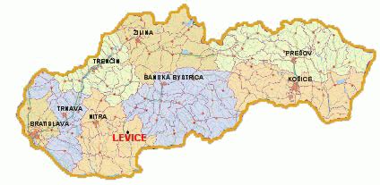
Slovakia ( ; Slovak: Slovensko [ˈslɔʋenskɔ] ), officially the Slovak Republic (Slovak: Slovenská republika [ˈslɔʋenskaː ˈrepublika] ), is a landlocked country in Central Europe. It is bordered by Poland to the north, Ukraine to the east, Hungary to the south, Austria to the southwest, and the Czech Republic to the northwest. Slovakia’s mostly mountainous territory spans about 49,000 square kilometres (19,000 sq mi), with a population of over 5.4 million. The capital and largest city is Bratislava, while the second largest city is Košice.
The Slavs arrived in the territory of present-day Slovakia in the fifth and sixth centuries. In the seventh century, they played a significant role in the creation of Samo’s Empire. In the ninth century, they established the Principality of Nitra, which was later conquered by the Principality of Moravia to establish Great Moravia. In the 10th century, after the dissolution of Great Moravia, the territory was integrated into the Principality of Hungary, which then became the Kingdom of Hungary in 1000. In 1241 and 1242, after the Mongol invasion of Europe, much of the territory was destroyed. The area was recovered largely thanks to Béla IV of Hungary, who also settled Germans, leading them to become an important ethnic group in the area, especially in what are today parts of central and eastern Slovakia.After World War I and the dissolution of the Austro-Hungarian Empire, the state of Czechoslovakia was established. It was the only country in central and eastern Europe to remain a democracy during the interwar period. Nevertheless, local fascist parties gradually came to power in the Slovak lands, and the first Slovak Republic existed during World War II as a partially-recognised client state of Nazi Germany. At the end of World War II, Czechoslovakia was re-established as an independent country. After a coup in 1948, Czechoslovakia came under communist administration, and became a part of the Soviet-led Eastern Bloc. Attempts to liberalise communism in Czechoslovakia culminated in the Prague Spring, which was crushed by the Warsaw Pact invasion of Czechoslovakia in August 1968. In 1989, the Velvet Revolution peacefully ended the Communist rule in Czechoslovakia. Slovakia became an independent state on 1 January 1993 after the peaceful dissolution of Czechoslovakia, sometimes known as the Velvet Divorce.
Slovakia is a developed country with an advanced high-income economy. The country maintains a combination of a market economy with a comprehensive social security system, providing citizens with universal health care, free education, and one of the longest paid parental leaves in the OECD. Slovakia is a member of the European Union, the Eurozone, the Schengen Area, the United Nations, NATO, CERN, the OECD, the WTO, the Council of Europe, the Visegrád Group, and the OSCE. Slovakia is also home to eight UNESCO World Heritage Sites. The world’s largest per-capita car producer, Slovakia manufactured a total of 1.1 million cars in 2019, representing 43% of its total industrial output.

Top Slovakia HD Maps, Free Download 🗺️
Map
Maps
United States
United States
World Map
China
China
