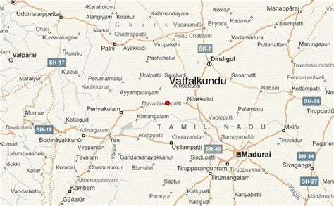
Location: Vattalkundu 🌎
Location: Vattalkundu, India
Administration Region: Tamil Nādu
Population: 29054
ISO2 Code: Tamil Nādu
ISO3 Code: IND
Location Type:
Latitude: 10.1655
Longitude: 77.7594
Batlagundu is a town in Nilakottai block in Dindigul district in the Madurai Region state of Tamil Nadu, India. The name Vetrilaikkundru (Betel leaf hill) later transformed and changed to Vathalagundu. The town is the major gateway to Kodaikanal. Subramaniya Siva was a writer, Indian Freedom Fighter, and activist born in Batlagundu. Batlagundu is the fifth-largest town in the Dindigul district. The town is located in such a way connecting three main districts of South Tamil Nadu (Dindigul, Madurai, and Theni). Batlagundu has most of the voters in Nilakottai Constituency.
Batlagundu is closely associated with Agriculture. The Town has many agricultural lands. It has a big market getting all the vegetables and fruits afresh from the Kodai hills. Batlagundu is an important hub in the Dindigul district. The Town is home to various banana and coconut productions.
The town is believed to be significant antiquity and has been ruled at different times, by the Pandiyan, Cholas, Madurai Nayakas and the British.

Top Vattalkundu HD Maps, Free Download 🗺️
Map
Maps
United States
United States
World Map
China
China