Villa del Carbón is a municipality located in the northern part of Mexico State, just northwest of Mexico City. While the town and municipal seat of Villa del Carbón is the largest in the municipality, it is not the oldest. The municipality contains a number of villages of Otomí and Nahua origins, in which much of the indigenous culture still survives. The municipality’s territory was defined in 1714 when a region known as Chiapan, split into what is now Chapa de Mota and Villa del Carbón. At that time, however, the community which is now a municipal seat did not have an official name; it was known first only by the name of its church Nuestra Señora de la Peña de Francia, and later by being a major supplier of charcoal. This would lead to the name of Villanueva del Carbón de Nuestra Señora Santa María de la Peña de Francia, which eventually shortened to Villa del Carbón. The major portions of the municipality’s glyph, which serves as it coat-of-arms, does not reflect the town of Villa del Carbón but rather two of its oldest communities: Taxhimay and San Lorenzo Pueblo Nuevo.The municipality covers an area of 356.14 km2 and has a total population of 39,587 (2005 census). Of this total, 8,029 live in the municipal seat of Villa del Carbón and the rest live among the other 57 communities which rely on the seat for government purposes. The municipality border the municipalities of Jilotepec, Jiquipilco, Tepotzotlán, Nicolas Romero, Chapa de Mota and Morelos in Mexico State, with Tepejí del Río, Hidalgo State bordering it to the north. The municipality is divided into three “barrios” or districts named Pendo, Centro, and Taxhihué.
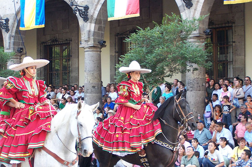
Today, the municipality’s economy is based primarily on tourism, as it has a number of streams, rivers and dams suitable for water sports, trout-fishing and camping facilities. It is also the home of a nationally recognized charreada(a type of rodeo) venue, that hosts major events.